High-Accuracy UAV Photogrammetry & Orthomosaic Services

We provide specialized UAV photogrammetry services for producing high-accuracy orthophotos and digital orthomosaics. These products achieve spatial resolutions of up to 1–3 cm/pixel. We utilize advanced industrial UAV systems, Ground Control Points (GCPs), and cutting-edge photogrammetric software. As a result, our drone surveying company generates georeferenced datasets fully compatible with modern GIS and CAD applications.

High-accuracy orthomosaic produced through UAV photogrammetry in Omorfokklisia, Galatsi, Attica, Greece, showcasing professional Photogrammetry Services Greece.

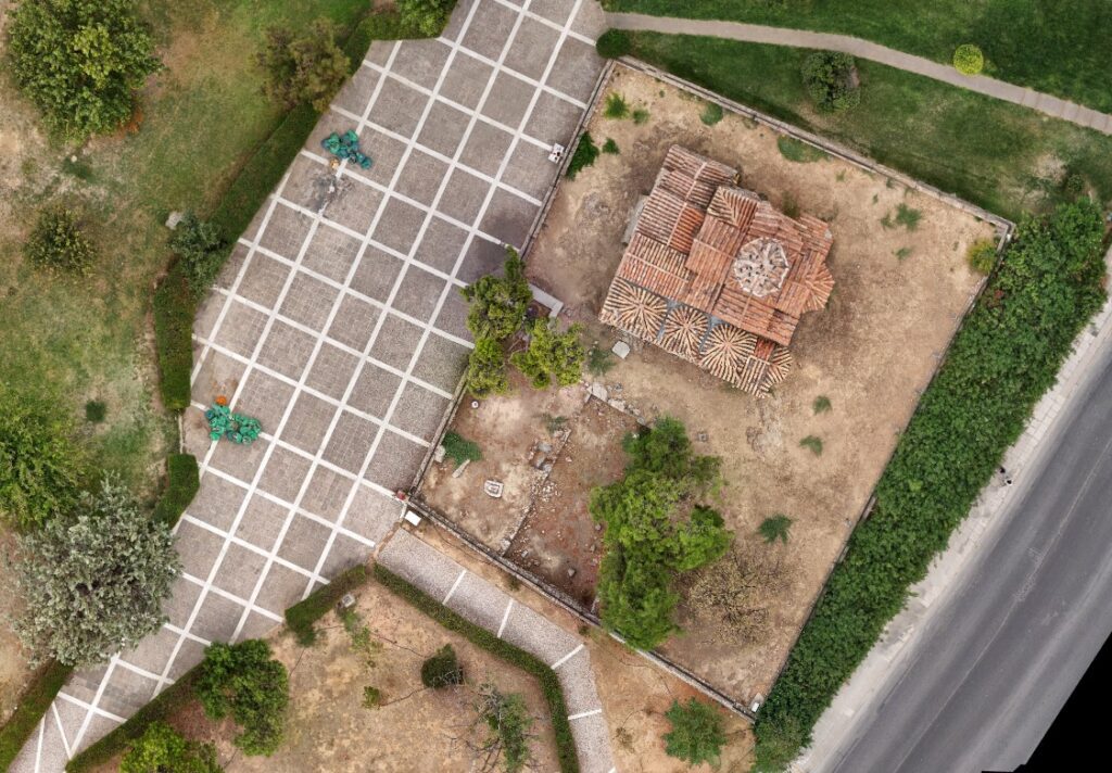
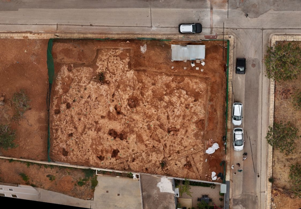
High-resolution orthophotos are a valuable tool in archaeology. They support the precise documentation and digital recording of archaeological sites and artifacts. In addition, they help professionals monitor ongoing developments during excavations, conservation projects, and enhancement works. Furthermore, these datasets are particularly important when surveying plots or rural areas that contain sensitive ancient remains. They ensure absolute precision in mapping boundaries, terrain features, and existing structures.

At the same time, our professional drone GIS mapping and aerial surveying services support civil engineers, topographers, surveyors, architects, and infrastructure authorities. We provide highly accurate data for environmental studies and as-built surveys. Moreover, we deliver all datasets promptly and reliably. Every project also includes full expert technical support.

Case Study: Drone Orthomosaic Mapping Services for Archaeological Clearance in Attica

The Challenge
A private investor required an immediate drone photogrammetry and orthomosaic mapping service for a construction plot under 1,000 sq.m. in Koropi, located in the Mesogeia region of Eastern Attica.The investor had purchased the land for the development of a modern residential apartment building. However, the authorities could not issue construction permits without official clearance from the Archaeological Service. Ancient residential stone wall ruins were present on the site. Therefore, the project required highly accurate, detailed, and indisputable visual documentation to accelerate the verification and approval process.
Our Approach
To meet the tight deadline without compromising quality, we conducted a rigorous preliminary drone site inspection. First, we assessed terrain obstacles, structural heights, and vegetation. This detailed field assessment enabled us to pre-compute optimized multi-directional flight paths tailored to the plot’s layout for photogrammetry services execution. We completed this planning phase before launching the mission. Furthermore, we combined synchronized flight grids with high-precision Ground Control Points to ensure optimal orthomosaic data quality. As a result, we captured every geometric detail of the ancient masonry from multiple angles. This approach ensured maximum data density and absolute accuracy during the subsequent photogrammetric processing stage.
Drone surveying and orthomosaic mapping services for archaeological documentation in Koropi, Eastern Attica, Greece, using advanced photogrammetry techniques.
The Outcome
We operated with maximum efficiency and delivered the complete georeferenced dataset within 24 hours. The deliverables included high-resolution source images in .JPG and .RAW formats. In addition, we provided comprehensive GIS-ready orthomosaic files in .TIFF format captured from multiple operational altitudes. Moreover, we maintained direct communication with the responsible public authorities. We confirmed data receipt and offered immediate technical assistance whenever required. As a result, we minimized potential delays and ensured that the investor’s documentation file fully supported the official review process.

LET'S FLY

Perigon Perspective © 2026. All rights reserved.